GET A FREE QUOTE TODAY - CALL US UK 07765252915 kevin.saunders@dmands.co.ukwww.dmands.co.uk
ADVANCED SURVEY MAPPING AND REMOTE SENSING
ADVANCED SURVEY MAPPING AND REMOTE SENSING
Get the help you need, from professionals
who are leaders in their fields.
Get the help you need, from professionals
who are leaders in their fields.
OUR SERVICES
Digital Mapping and Survey were founded in 2009 by a Geospatial, GIS and remote sensing specialist with 21 years of experience global . The owner has vast international experience in the survey and mapping industry. Digital mapping and survey were one of the first companies in the UK to embrace and maximize the potential of drone technology. DM&S have worked on small scale one day projects aw well as large 15 billion Dollar 150km infrastructure projects and revision mapping of entire countries
Cost effective precise Aerial mapping
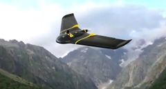
Digital Mapping and Survey was already in the aerial imagery and mapping industry when drone tech became commercially available in the UK . DM&S was one of the first companies to embrace the cost effective and accuracy opportunities that drones have provided. Drone imagery has allowed small and large projects to be mapped precisely and cost efficiently

Precision Surveying
Digital Mapping and Survey uses precision Ground survey GPS equipment to enhance, check, infill and help control mapping. Digital Mapping and Survey also ground surveying capabilities. Surveys include: Topographic, Planning, Environmental, monitoring, measured, volume, exploration and resources
Geospacial Solutions
Digital Mapping and Survey is the answer to Geospatial requirements. The managing director has over 30 years experience in the remote sensing and geospatial industry.
3D Models Images and Video
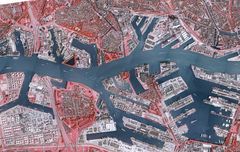
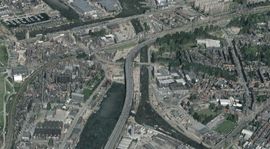
Digital Mapping and Survey are one of the leaders in 3D capture and modeling. We have been creating 3D data for mapping, orthophotos, DTM, DSM, volume calulations, 3D visualizations, Planning, exploration and monitoring
ABOUT US
Digital mapping and survey was founded in 2009. The owner was already an experienced geospatial specialist with over 20 years in the industry. With thousands of projects completed some small and some national mapping, it was the perfect opportunity to use new technology to offer precise cost effective mapping and data capture for the geospacial industry.
Digital mapping and survey offer many options. These include traditional Ground surveying: Accurate: RTK aerial data capture. Data capture for aerial imagery: several aerial data capture platforms including rotary and RTK fixed wing. We can offer high tech data capture using multi spectral cameras and sensors.
Products include: Survey Drawings,Topographic Surveys, terrain models and surface models, Volumes, Orthophotos, 3D models and visualizations , measured surveys and monitoring surveys, Boundary disputes, Planning surveys and engineering surveys
Build yourown world

FULLY CIVIL AVIATION AUTHORITY LICENSED AND APPROVED
Digital mapping and survey. 30 Years of experience in the remote sensing and geospatial environment
GET A FREE QUOTE
CONTACT:kevin.saunders@dmands.co.ukMOB: UK 07765252915
ALL YOUR 3D SURVEY AND MAPPING REQUIREMENTS
CONTACT
CONTACT
MOB: UK 07765252915
kevin.saunders@dmands.co.uk
MOB: UK 07765252915
kevin.saunders@dmands.co.uk